leelaurelsGS – Empowering Decisions. Optimizing Processes.
leelaurelsGS – Empowering Decisions. Optimizing Processes.
Introduction
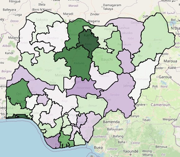
Population data is the backbone of infrastructure planning, disaster response, business expansion, and socio-economic development. With Meta’s high-density population datasets, we can now analyze population distribution at an unprecedented resolution—down to ward, LGA, and state levels in Nigeria.
But why does this matter? When combined with Terrain, Elevation, Climate, Obstacles, and Population data, population mapping becomes a powerful tool for:
✔ Business intelligence (market potential, logistics optimization)
✔Humanitarian operations (disaster risk assessment, aid distribution)
✔ Urban planning (road networks, housing, utilities)
✔ Public health (disease spread modelling, vaccination campaigns)
This blog merges technical geospatial workflows with real-world applications—showing how we at leelaurels combine population + Terrain (slope, landforms), Elevation (altitude, flood risk), Climate (rainfall, temperature), Obstacles (rivers, forests, infrastructure) to drive Decision-Making
In this blog, we’ll explore:
Population Data Extraction
Meta (formerly Facebook) provides high-resolution population estimates using:
Technical Workflow: Geospatial Extraction & Mapping
To generate ward, LGA, and state-level population maps, we followed these steps:
Step 1: Data Preparation
Step 2: Zonal Statistics Extraction
Step 3: Visualization & Cartography
Output:
Ways we can help you leverage on Population Intelligence as Competitive Advantage and to drive Decision-Making
Conclusion
The extraction and integration of high-resolution population data with TECOP risk analysis creates:
Next Steps for Your Team: We can help you –
Need help implementing these solutions? Contact our geospatial risk & decisions specialists for a customized assessment. (info@leelaurelgs.com, +2348062905881, +2348070321929, +234817409633)
References:
Meta High-Resolution Population Maps
IOGP (2023) Guidance on Community Engagement in Oil and Gas Projects
World Bank (2022) Geospatial Analysis for Energy Infrastructure Planning
NNPC (2023) Niger Delta Regional Risk Atlas
In the high-stakes world of oil and gas, Technical, Economic, Commercial, Organizational, and Political-Societal risk factors. (TECOP) risk factors determine whether projects succeed or fail. But there’s an often-overlooked dimension that directly impacts all five TECOP elements: local population dynamics and socio-economic conditions
How Population Data Strengthens TECOP Analysis
Population Exposure Audit for existing facilities
Pipeline Routing Optimization
Community Relations Strategy
Security Risk Assessment
OTHER AREAS OF APPLICATION INCLUDE
Humanitarian & Disaster Response
Urban Planning & Infrastructure
Business & Market Analysis
Public Health & Disease Control
Telecom Tower Placement
Contact Us
leelaurelsGS
Tel +234 8177409633, +2348062905881,
email – info@leelaurelsgs.com
website – leelaurelsgs.com